This blog is about a trip to Chile from November 9 through the 30, 2016. Why Chile? Because we hadn’t been there before, and it has a lot of rugged, beautiful scenery. It didn’t disappoint. We chose to go in November, Springtime in the Southern Hemisphere, when the weather is better and the crowds haven’t arrived yet.
On the trip was Carole and George Leone, seasoned travelers in their late 60s and John Pocock, a long-time friend from his days as a student at Cal Poly San Luis Obispo. John was a first-time international traveler in his mid 30s, with a lot of experience in wilderness camping. Also along for the first two weeks was Hailey Corthell, John’s girlfriend who had recently returned from a vacation in Spain and Portugal. This was good because the other three’s Spanish was pretty rusty.
The plan for the three-week trip was to visit three different areas of Chile, starting from the far South in Punta Arenas / Tierra del Fuego, then fly North to the Lake/Volcano District, then fly further North and traverse the Atacama Desert. We finished with a couple of days at a surfing beach in Arica and one day in Lima, Peru on the way home.
Because of the great distances involved, we chose to fly between the major areas and rent cars for all other travel. This would be a change for George and Carole, who normally take trains and buses when they travel internationally. Thinking back, the last time we used rental cars for a whole trip was in Ireland in the mid 1970s.
Carole spent a lot of time researching different places to stay to avoid package-tour (or any) hotels. They ranged from simple hostels, to cabins, to Air BnB houses or condos. we managed to avoid heavily touristy accommodations except in Torres del Paine.
We found Chile to be a great place for outdoor activities and beautiful vistas, but not that exotic of a destination. People were nice, food great, prices equivalent to the U.S., roads well-marked and driveable (with notable exceptions off the usual routes).
This blog will give our friends and family more information, pictures and videos about the trip than we can in our annual Christmas newsletter, and also in the future to record pictures, memories and anecdotes about previous trips so there will be some record of them if anyone is interested.
Southern Chile
Day 1: Landed in Santiago and waited for the next flight south to Punta Arenas. About 15 minutes into the flight you start seeing individual snow-capped mountains and volcanoes, some with smoke plumes. Farther south the mountains start crowding together and the snow is deeper. Then you start seeing the glaciers and huge frozen lakes. Nearer to Punta Arenas the view includes waterfalls and liquid lakes with floating icebergs. You finally arrive at Punta Arenas airport and see the small planes with skids that take supplies to the Antarctic bases. Makes you realize just how far South you are.

Punta Areanas
Once we arrived in Punta Arenas we were very gad we brought all the warm stuff, even though it meant we packed heavier than we ever have (still only 1 medium-size suitcase and small backpack each). It was very cold and very windy. Traveled to our Hostel, met Hailey for the first time and walked all over looking for dinner. Finally found a noisy bar that served food along with a popular soccer game on TV.
Stayed for three days at Hostal Aventura Austral. A nice place on a quiet street, within walking distance of the main part of town. Good beds, good breakfast, really great hosts. Highly recommended.
Day 2: Picked up our rental car, hit the grocery store for provisions, visited an Indian/Tierra del Fuego natural history museum, and made plans for the next day.


Ferry to Tierra Del Fuego
Day 3 (Saturday): We took the car on a two-hour ferry from Punta Arenas to Tierra Del Fuego, one of the Southernmost inhabited islands in the world. Adventure! It’s remote, beautiful and cold, windy. All roads in Tierra del Fuego are gravel roads, but maintained fairly well, and there are miles and miles of pampas, with few buildings or even fences. We must have driven at least 200 km and passedabout 8 cars all day (and no gas stations).


Saw hundreds of Guanacos (like short-coated llamas, but wild), a fox, several dozen flamingos and King Penguins! Chilean Tierra del Fuego has one of the most Northern flocks of King Penguins, who mostly live on the islands around Antarctica. These penguins have colorful markings and are taller (about 4 feet) than the more common Magellanic Penguins (with a similar-colored coat, Carole could have totally blended in).
Video courtesy of John Pocock
We drove about 1-1/2 hours to a tiny national park to see them. Totally worth it. After that, we had to choose between returning to civilization or driving further south to the middle of nowhere. Right, nowhere it is.
The map of Tierra del Fuego includes the names of various locations and we kept thinking it would be a small town or village. Nope. We passed through zero towns except the first one where we landed off the ferry. The names on the map were either abandoned areas or mines or natural gas plants.

On the way to the return ferry that evening George was driving. He suddenly lost control of the car’s rear end in a turn at 70 mph on a gravel road. We zigged then zagged about six times and went off and back on the road during a couple of them. What we didn’t know was that the rear tire was flatting! Fortunately we had a full-sized spare. The flat tire had about 10 major holes in it; worst we have ever seen! We then looked at the other tires and realized that all of them were really worn and a front tire was installed inside out!

Drove on another 60 miles (100 km) to the ferry, very low on gas. No gas stations anywhere. At dusk (9 p.m.) we finally stopped in a town on the mainland and asked about gas at a tiny general store. They told us the nearest gas station was 50 kilometers away and closed an hour ago. Yikes! We were on fumes. Finally one of the shopkeepers agreed to take us to his home and sell us 20 liters (5 gallons) of gas so we could drive back to Punta Arenas, about 120 km away. Made it back by 11 p.m.
Our first successful survival story of the trip!
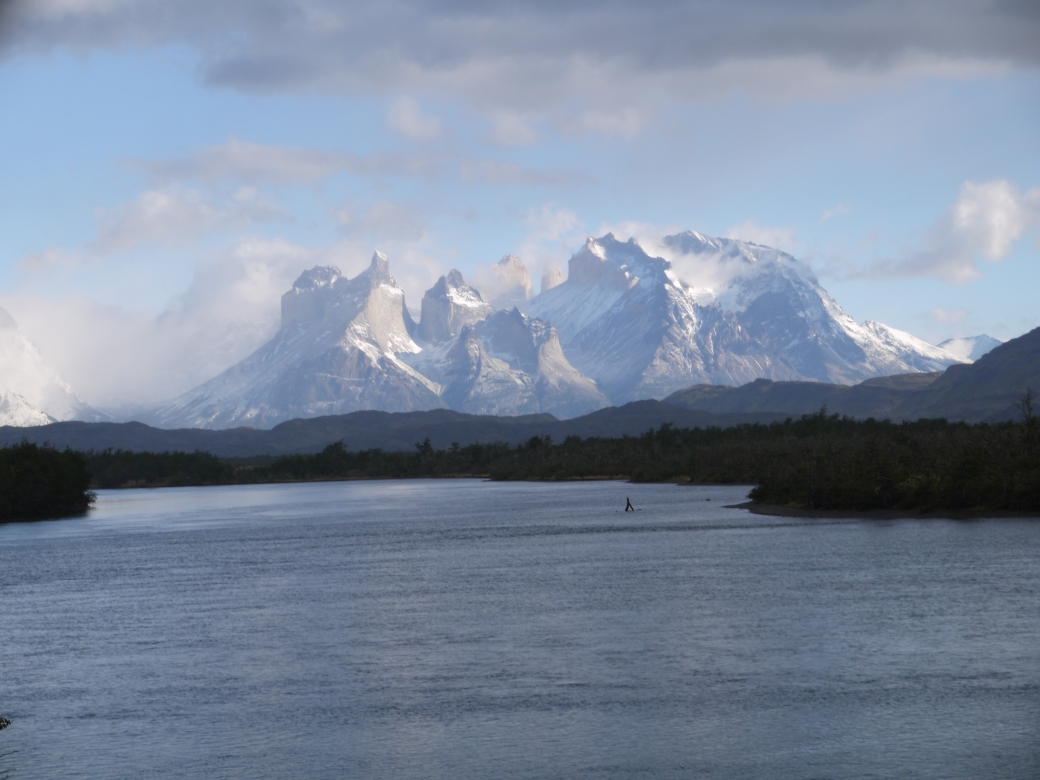
Day 4 Couldn’t get a spare tire in Punta Arenas (it was Sunday and everything was closed), so we just drove to Torres del Paine National Park, about 3 hours away (had to go; we had a prepaid room). Stayed in Puerto Natales several hours as John and Hailey searched for a camping tent to rent. Another stop for groceries and we were on our way to the most photographed place in Chile.
When we got to Torres del Paine it was stunning scenery, but the “Torres” (towers) were mostly hidden in the clouds. When the clouds parted, it was like when you come out of the tunnel in Yosemite for the first time and suddenly see Half Dome and the valley.
Stayed three nights at Cabanas del Paine near the park entrance. We had a duplex cabin with three beds for $220 per night. Yikes! Views were beautiful though and the cabin was warm at least.
Food was outrageously expensive, $40 per person for an average-quality buffet. So for dinner that night we used John’s tiny camp stove to make burritos in batches, which Carole and Hailey washed down with an excellent Chilean red wine Carminere.
Day 5: In Torres Del Paine National Park. Drove 1-1/2 hours to take John & Hailey to the drop off point for their overnight camping trip among the towers.


George and Carole drove further on to a great waterfall and spent several hours trying to get a good photo of the towers while they played peek-a-boo with the clouds.
Day 6: The day was cold, windy and rainy. Spent much of the day indoors and left in the afternoon to retrieve John and Hailey. Enroute, stopped to hike to a different waterfall. It was cold, gale-force winds so only went a kilometer or two before giving up.


After we picked up John and Hailey we saw an adult puma crossing the bridge just ahead of us!
Day 7: Clouds finally dissipated long enough to get some good photos from the lodge, then headed back to Punta Arenas.
We ended up driving for four days without a spare tire after the flat in Tierra del Fuego including all kinds of gravel back roads in Torres Del Paine National Park. Another flat would have involved hitchhiking with a tire for 120 miles each way after abandoning the car (and maybe sleeping in it). Big relief when we got a used tire in Puerto Natales.
Then, Did we learn our lesson from a few days ago that in Chile you always refuel when you see a gas station? Nooooo. At this point we had 2/3 of a tank of fuel left. We figured that was enough to get us back to Punta Arenas Wrong! We forgot about the head winds. About 70 miles from our goal (and the nearest gas station) the gage was showing almost “empty”. We drove the remainder of that day coasting down every possible down slope to save fuel. Made it on fumes.

Stayed that night at a great hostal ” La Casa Escondida”, about 10 miles out of town and near the airport. It was in a grove of local trees (rare in Patagonia) and the hosts Maurizio and his mother Edita were far and away the nicest we met on the whole trip.
Southern Patagonia is very large and lightly inhabited. The only village of any size was in a grove of local trees (rare in Patagonia) and the hosts Maurizio and his mother Edita were far and away the nicest we met on the whole trip. between Punta Arenas and Puerto Natales is Villa Tehuelche (population 150). We stopped to make sandwiches here and found the local fiesta area complete with rodeo arena. I think this town has the only school for miles and miles.
week-2-puerto-varas-and-caburga
Day 8: Two hour flight north to Puerto Montt, the beginning of the Lake District. Picked up the rental car (checking tires carefully this time!). Drove an hour north to our cabin near Puerto Varas. The cabin was within 500 feet of Lake Llanquihue but you had to climb a straight-down ladder to get there. George made it but Carole decided the view was better from the top!
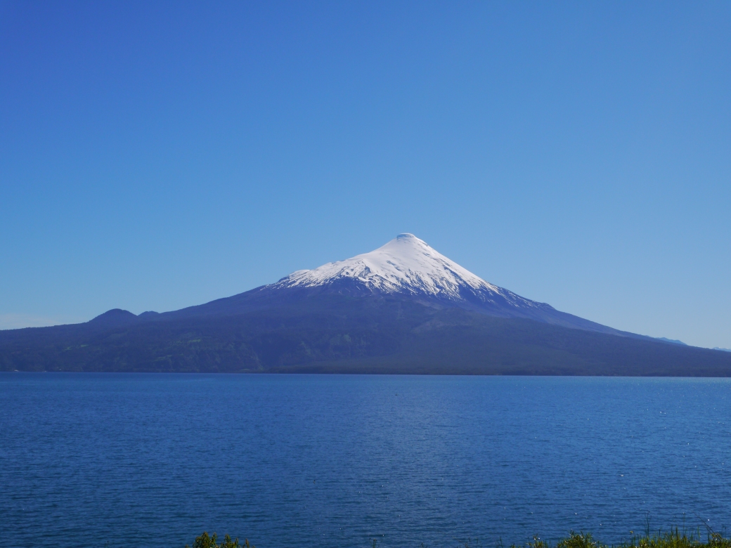
Lake Llananquihue and Volcano Osorno
Day 9: All four of us drove up the winding road to Volcano Orsono, which has a ski resort on one side. Took the chairs as far as we could, then hiked to the inactive volcano’s cauldron. John raced us on foot down the slope while we took the chairs. He won by a good margin! We had lunch at a roadside turnoff while watching Calbuco, the volcano next door, venting smoke off the top, breathing in and out like a signal fire. Also drove to a stunning waterfall (local attraction) and a smaller lake near the border with Argentina.
Day 10: Today John and Hailey were dropped off in town to rent mountain bikes and George and Carole drove to see a small fjord area to the south, way off the main route. A good two-lane graveled road led to a narrower graveled road, which led to a barely-graveled, one-lane road with a couple of really iffy old wood bridges, barely wide enough for the Citroen to drive over, with no sides. Kind of a bug-eyed ‘aim and gun it’ situation and hope the inertia of the car saves us from any mistakes or collapse. (which worked). The end result was a picnic at a beautiful tidal estuary fishing village with mountains right down to the water level. Really reminiscent of Switzerland. Returned to find out that John and Hailey never found bikes to rent so they toured around town instead.


We stayed 3 nights at Cabinas Bordemundo, which is about 3 kilometers outside of Puerto Varas. Four nice cabins, if a bit small, and a very gracious owner, Javiera. The cabins have kitchens and Javiera brought eggs and fresh-baked bread daily.
Day 11: Drove North about 3 hours to Pucon, still in the Lake District. Finally warmth! In the Chilean summer, this area is filled to the brim with tourists. We were there in the Chilean springtime and while very busy, it was still manageable. Our hotel/cabins were in nearby Caburga and we took the “more interesting” road getting there, basically a dotted line on the map that approached it from the opposite direction. What could possibly go wrong? Well, it was narrow with crumbling edges of small cliffs, incredibly steep gravelly sections with tight, blind corners and a lot longer than the funky tourist map showed. But hey, we got there! Glad John was driving as he drives dirt roads daily commuting to work out in the wilds of Nevada.
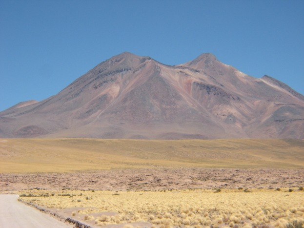
We spent two days at one of the most peaceful, beautiful lodgings ever on all our trips, Hotel Salto de Carlieuful. Our spacious, two-story, two-bedroom cabin had a view of the classic Volcano Villarica, which was steaming a cloud all the time. At night you could see the internal glow reflected off of the steam and ash cloud. It has the perfect volcano shape, like your science fair project with vinegar and baking soda, but covered with snow.


View of Vocano Villarica from our cabin
However there are “Danger, Volcano” signs all over, big signs with evacuation routes, because they had a big eruption about 10 years ago. In fact, all during our travels we were either seeing “Danger, Volcano Evacuation Area” signs or “Danger, Tsunami Evacuation Area” signs.
The cabin was in a grassy area close to the main building which had an Italian restaurant and a wood-heated hot tub right next to a “salto” (waterfall) that is lit up at night. You could reserve the hot tub for 1/2 hour increments. We took advantage of that every night.

Day 12: We dropped off John and Hailey to pick up their mountain bikes, then we headed East to a remote National Park with only hiking trails. We took the least difficult forest path that followed the lake for a few kilometers. Great time!

Day 13: Spent the day going to a paid attraction, “Tres Saltos” (three waterfalls) then to a Mapuche Indian village. Tres Saltos was a series of waterfalls on private property. The bottom one was beautiful and had a bridge to cross over. We did that, then George found a path that headed up to the second waterfall. Carole declined to join him, so George headed up solo.

Headed “up” is an apt description as he found himself climbing up a few rock faces and tree roots, but he finally made it to the second waterfall. He then found what appeared to be the route that continued to the top waterfall, by again using climbing techniques, under a rock overhang and holding onto small trees, all the while following the faint clues on the path. The third waterfall was great too, but then he had to retrace the route all the way down, including the sketchy boulders and tree roots. After finally returning to flat land with some great pictures, we headed back to the car only to find a sign pointing to the “Stairs to Waterfalls 2 and 3”. Oh well.

Route to Waterfall #3

Successful survival day #2!
After picking up John and Hailey in town we headed Northwest toward Freire, where we had a house reserved using Air BnB. We chose this place because it was fairly close to the airport in Temuco and because it had a WASHER AND DRYER!!! The place is owned by Morrie from Oregon, a retired farmer/helicopter pilot who spends summers in Oregon and winters in Chile. It was a beautiful house right alongside a river. Carole and Morrie had corresponded for a few months and he happened to be there. He graciously offered us a ride up-river on his boat and a Salmon dinner afterward.

Sadly Hailey had to leave us then so that she could be home for Thanksgiving. She started her journey back that night by flying from Temuco to Santiago.
Day 14: Flight from Temuco to Santiago, wait 2 hours, then flight to Calama in the Atacama desert. The Atacama desert is the driest desert in the world. Some areas here have never recorded rain since they started measuring in the early 1800’s.
Picked up a rental truck: dual cab diesel Chevy, with extra 5 gallon fuel can. It cost a lot more but it was worth it. Drove to San Pedro de Atacama, a real mud-brick pueblo overrun by turistas. Narrow winding streets that somehow cars and tour busses fit down. Beautiful desert colors at sunset. Since we were there in Springtime, the daytime temperatures were in the 70s and 80s.


There is only one gas station in San Pedro, and it’s in a cul-de-sac. Glad we found it! The only other gas stations in the entire area are in Calama, 45 minutes away.

We stayed two nights at “Hostal Quinta Adela”, which was basic but comfortable. In San Pedro you park your car and walk most everywhere. Our Hostal was about a 15 minute walk from the main Plaza.

Day 15: We went up to a couple of high altitude (altiplano) lakes (13,000 feet) via a dry (almost) salt lake with flamingoes you could get quite close to. We saw flamingos all through Chile, from sea level to 13,000 feet as well as Guanacos.


At the high lakes Carole started having some altitude sickness symptoms (dizzy, difficult breathing) so we stayed awhile but drove to a lower altitude sooner than we wanted. On the way, we tried a road that was so poorly marked we turned back. It seemed iffy, going over a hill into a valley, with the road splitting and no signs on a 30 degree slope. Sketchy, we thought, but we had no idea what lay in store for us 2 days later.


In the late afternoon John and George hiked up a narrow slot canyon near town. It had mud walls 80 feet high for about a mile and lots of bike tire tracks. The light was amazing.

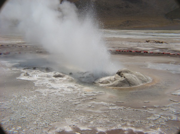
Day 16: After refilling the gas tank we traveled first to the “El Tatio” geysers. These are the highest altitude geysers in the world, and it takes about 2 hours of driving/climbing to get there. They were interesting, but Carole again showed signs of altitude sickness (they were at 14,000 feet) so she had to be satisfied by looking at George’s pictures of them.

Next was a series of back roads to Calama (last gas station for a while!) via another dotted line lonley traverse through the dry spiky mud beds. Our destination was our cabin for the night near Pica, about a 4 hour drive from Calama.
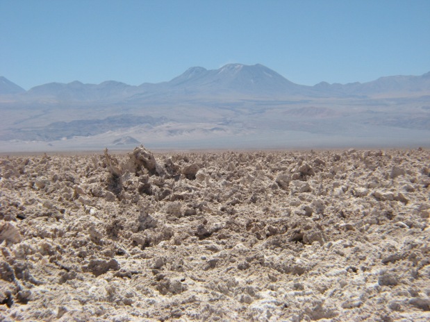


If there is a typical landscape in the Atacama, it’s dried salt mud, which is similar to spiky, chunky concrete. Miles and miles of it, interspersed with multi-colored dirt mountains then valleys, then hills, then dirt canyons with sand sides incredibly deep, as much as 5,000 feet deep. It often took as many as 20-30 miles to drop from the top of one to the bottom, then the same to climb out of it.
We had dinner in Pica, a pretty oasis village in the middle of nowhere, got fuel again (we’re learning!) then traveled another 30 minutes to our place for the night, Cabana El Huarango.


The owners created the cabin and other buildings from local salt-mud and recycled materials. They recycle everything and use solar for water, electricity and cooking (using parabolic reflectors). They are the Real Deal and John and George enjoyed Marco’s tour of his shop. The cabin was very comfortable and we wished we could have stayed longer. Marco, the builder/owner, had a pet lizard — a wild one he fed in the dining area.


Day 17: We drove through more Martian movie landscape many times, absolutely no life. We were about an hour from Arica when we looked at the map and decided to take a back road loop that went further into one of those deep canyons we had been crossing all day. Turned out we weren’t on the road we thought we were . We will probably have real nightmares over what happened next. All we can say is this is what happens when you put three people together who don’t say “no” to unknown adventures.

You know those “Most Dangerous Roads in the World” things you see on TV or Facebook? Well, we had a real one. The road we chose was paved for a while and wound down into a green valley, then changed to dirt (no big deal, normal for Chile). The dirt road then started to climb steeply out of the valley, through switchbacks. But it was a solid, graded road and had tire tracks in the surface dust, so we knew that it had been used. We forgot that in the Atacama there is no rain, so the tracks might have been very old, but looked recent.
The hillsides had no vegetation at all, just rocks and loose dirt. You don’t realize how full of life most our deserts are, with sagebrush, succulents and scrub brush.

We started climbing through switchbacks and climbed and climbed and kept going up, up, up. The road was carved out of a 45 degree+ dirt mountain, but going up at a fairly level angle. It then started to get a bit narrower, about 1-1/4 lanes wide at most. Then we were right on the edge, with little or no room next to the road before it went straight down, all the while zigging and zagging and avoiding large rocks.
After 2 hours we reached at least 4,000 to 5,000 feet above the valley, staring down this steep slope, trying to get to the top. Before we reached the summit, the road (just a lane wide now) started downward again. We stopped here and got out the binoculars. Even with the binoculars we could barely see the dirt road in the valley below, then we finally saw it rise up again with lots of switchbacks maybe 10-12 miles away.
 In George’s words: “All those years installing and repairing solar arrays on roofs made me pretty comfortable with heights, unless I was working close to the edge of three stories or more. That’s exactly how I started to feel, really vulnerable, where one wrong move could be fatal. The feeling crept up on me and I started trying to lean into the mountain, even though I was in the back seat.”
Good that John was driving with his considerable off-road experience (afterwards, he said it was one of the sketchiest things he had done, and most of those sketchy things lasted about 5 minutes, not 2 hours up and 1-1/2 hours back.).
At that point it became way too sketchy for all of us so we stopped and decided to turn back. But turning around required going forward another couple of miles until we found a spot where we could do a multiple YYYY turn with George standing on the edge so John wouldn’t break the edge down and go over. Carole was in the front seat with her eyes closed at this point.
After turning we then had to drive back to the top and down to the valley where we started. Another 90 minutes of fear, but better that the first time. When we got to the bottom about 5 p.m. George took over driving and John fell promptly asleep in the back seat, exhausted from the effort.
Made a good story once we knew we were going to survive, which wasn’t until we reached the valley floor.
Successful survival day #3!
Finally made it to Arica with some daylight to spare. It was a shock to be driving in a city after so many days of seeing empty spaces. We had a Google map, but couldn’t find street signs so it took awhile to find our condo.
Day 18: We stayed two nights at a two-bedroom condo with an ocean view. (Good: space, kitchen, balcony, view; Bad: 4 story walk-up, no towels or bathmats). John took the truck and left for the day to see the high altitude areas near the Bolivian border, and Carole relaxed on the balcony and read a book nowhere near a car or truck.
George rented a wet suit and surfboard for a popular local surf school. The “school” was a true surfer’s crash pad with the owner sleeping on the roof patio at 1 p.m., rooms everywhere, guys and girls (“surf instructors”) walking around in flip-flops and shorts with salty hair. George says “I felt I’d been transported back to the late ’60s beach scene (yeah, I was there). The smell of the “incense”, shall we say, from one of the rooms completed the picture perfectly”.
John finally returned from the far reaches of Chile about 9 that night with stories of road construction delays of 1 to 2 hours at a time.
Day 19: Stayed at the condo until 11 a.m. (George surfing, John sleeping) then drove to an out-of- town museum on a historic olive farm that featured ancient artifacts and mummies. Turned in the car about 3 and headed across the border to Tacna, Peru. Being in the bus station in Arica really brought back memories of our 1974 trip to Peru. Carole was watching our suitcases among the colorful, multi-skirted Bolivian women waiting for the bus to La Paz and reminiscing about going to Cuzco before it became a major overcrowded tourist destination.
Crossing the border into Peru consisted of waiting in line for about an hour until all the Chilean officials came back from their long afternoon break. Our driver did the paperwork and had his car searched just like everyone else’s car, even though he makes the trip several times a day.
We got our passports stamped to exit Chile, then drove 100 yards to the Peruvian entry point. Their building was more fancy that Chile’s, and the entry line was very quick. But cars trying to exit Peru were waiting in a long, long line, while the official in the exit booth just walked away. The cars started really honking loud and long! Chileans drive very much like U.S. drivers; Peruvians drive in perpetual chaos that amazingly works.
Stayed in Tacna that night to be near to the airport and our 9 am flight the next day. Hotel Tambo Real was inexpensive but nice, with soft towels and as much hot water as you could want!
Day 20: Flight from Tacna to Lima. We were supposed to be met by a guide and car for the day, but they glitched the schedule and we had to wait a couple of hours for them to arrive. We then had a guide to show us through downtown Lima (a lot better than it was in 1974) and some key museums.
Having a driver in Lima was a survival move since Peruvians will fit a car into any open space (however small) and lanes are whatever you want them to be.
Our downtown guide was a former special education teacher who was getting another degree in tourism. She talked about the history, politics and culture of Lima and Peru. One of the places we went was a part museum/ part church that had catacombs with thousands of bones beneath the church. Many of the bones were in round stone pits. One pit would be just leg bones, another skulls, etc.
After all that death the guide took us to the Larco Museum, which had artifacts from Incan and many pre-Incan cultures. Lots of gold, silver, precious stones and pottery. One section featured ancient graphic sexual pottery. They said it was not only to remind us of what life is about, but also as symbols of fertility. This kind of ancient pottery is quite common in this part of the world — it must have freaked out the Spaniards with their Catholic and Islamic influenced culture!
That evening we visited a Lover’s Park on a bluff overlooking the ocean. Some surfer’s were out in front of the historical Waikiki Surf Club (founded in the early ’60s). That club might still own a few surfboards that George worked on for Rick Surfboards in the 60’s!
The owner of the tour company took us to dinner (ceviche and fried fish) to make up for stranding us at the airport that morning.
We then went to a big park filled with all kinds of water fountains, some huge, others small, all changing colors at random. Many did different things, like a 100 foot long area where streams of water arched overhead, make a tunnel you could walk through. Another fountain had round concentric streams that sprayed vertical on and off, at different heights. The object of the game was to run into it and get to the center, or between the circles of streams before it turned on again at random. Of course George did it, jumping between streams and only getting sprayed once!


Then it was off to the airport to home, leaving about 1 a.m.

Loved your card AND your story. I’m so proud to have you as my Aunt and Uncle! Your lives are true adventures.
LikeLike
I’m going to have nightmares just imagining that road. Loved the write up and photos.
LikeLike
Great adventures! Loved reading it x
LikeLike
Just happened upon your blog – what a treat to be able to live your adventures vicariously! Glad to see both of you alive and well!
LikeLike
Wow, what a fantastic trip, wonderful photos, and nice job summarizing as well as including the emotion you experienced. That road almost nauseated me! Thank you for sharing, and I’m happy that you had a safe trip with some fabulous new memories…
LikeLike
after the narrative you gave us at the salon, getting this travelogue was a great companion to the story. it made it so real. true adventure. the most interesting couple in the world. just ask Dos Equis beer commercial.
LikeLike